


Madagascar’s central highlands are one of Africa’s most underrated hiking regions. Within a day’s drive of Antananarivo you can wander through terraced rice fields near Antsirabe, climb volcanic domes in the Ankaratra massif, trek between Zafimaniry villages and tackle the granite ramparts of Andringitra and the Tsaranoro valley. This guide compares these main highland walking environments to help you choose routes that match your fitness, time and appetite for adventure, with realistic information on access, guides, camping, weather and gear.
Understanding the Highlands Hiking Environments
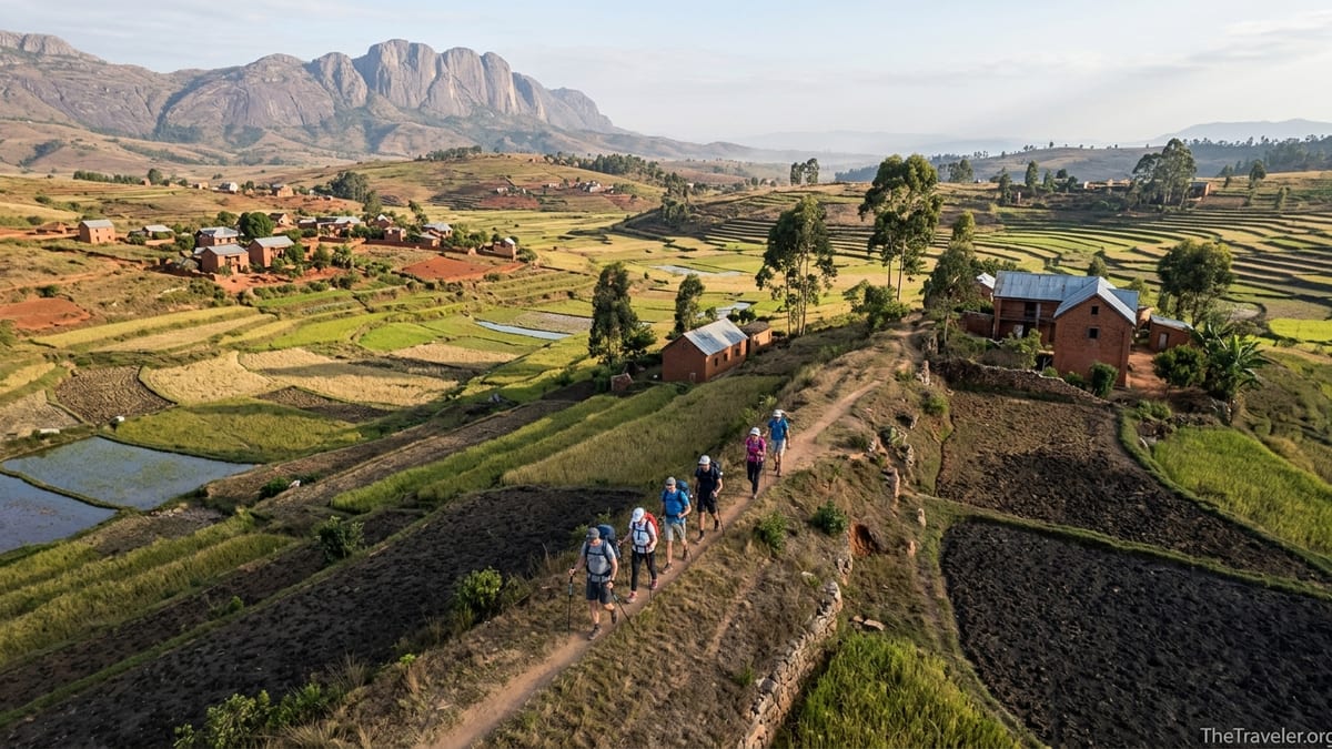
The Malagasy highlands form a long backbone of plateaus and volcanic massifs running roughly north to south through the centre of the country. Most travellers experience them along the RN7 highway between Antananarivo, Antsirabe and Fianarantsoa, but step a little away from the tarmac and you find very different walking environments. Around Antsirabe and nearby Betafo, paths thread between irrigated rice paddies, brick farmhouses and low volcanic hills at around 1,400 to 1,600 metres above sea level. These are gentle landscapes where you share tracks with children walking to school and farmers pushing zebu carts.
Further north, the Ankaratra massif rises above 2,600 metres, with planted pine forests giving way to subalpine grasslands and cool, misty ridges. South of Ambositra, the Zafimaniry country lies in a broken mosaic of forested valleys and steep ridges dotted with wooden villages, accessible by footpaths linking Antoetra with outlying communities. Much further south again, the granite walls of Andringitra National Park and the adjacent Tsaranoro valley create perhaps Madagascar’s most dramatic trekking arena, with peaks around 2,600 metres, deep canyons and long, rocky ascents.
Because these environments differ so much, planning a walk in the highlands is less about picking isolated “best hikes” and more about choosing the style of landscape and commitment you want. A half-day countryside walk from Antsirabe with a local guide might involve 10 to 12 kilometres and 200 metres of ascent, while a typical three-day Andringitra traverse will see you climbing more than 1,000 metres to camp on a cold plateau above 2,000 metres. Understanding these contrasts is the first step to building an itinerary that feels rewarding rather than exhausting.
Access also changes from one highland area to another. You can reach most Antsirabe and Betafo trailheads in a standard car or even by bicycle or pousse-pousse rickshaw, while Ankaratra usually requires a short diversion in a taxi-brousse or private vehicle to Ambatolampy and then a rougher secondary road to Manjakatompo. Zafimaniry villages are connected by dirt roads that can become muddy and rutted late in the rainy season, and Andringitra demands the most commitment, with long 4x4 tracks from Ambalavao or Ihosy to reach the Namoly or Tsaranoro gateways.
Easy Countryside Walks around Antsirabe and Betafo
Antsirabe, a spa town at roughly 1,500 metres on the RN7, is the natural base for gentle walking in the highlands. The region’s tourism office and several local agencies now map out half-day and full-day routes from town to Lake Andraikiba, Lake Tritriva and the rice terracing around Betafo, a small historic town about 20 kilometres west of Antsirabe. Many visitors simply hire a licensed guide through their hotel for a countryside loop that combines village visits, hot springs and viewpoints over the patchwork of paddies.
A typical Antsirabe day walk might start from the city’s cathedral, follow small roads through brickmaking quarters and then join footpaths between fields, passing farmers planting rice, women washing clothes in irrigation canals and children shouting “salama” from red-earth courtyards. Reaching Lake Tritriva, you can circle the crater rim on a narrow trail and picnic under eucalyptus trees, then descend another way to complete a wide loop back towards town. Distances are flexible: guides can adapt from an easy 8 kilometre ramble suitable for families to a 20 kilometre day that will tire out keen walkers but never feels technical.
Betafo and the surrounding Vakinankaratra countryside offer slightly wilder but still approachable hikes. Here the scenery shifts to volcanic domes, hot springs and classic stepped rice terraces, some of which have been proposed for UNESCO recognition. You might start in Betafo market, then climb on old footpaths used by villagers to reach small hamlets, churches and irrigated hillsides, gaining superb panoramas of the high plateau. Several trail circuits originally created for local trail-running events are now reused by trekking guides to offer day-long loops for visitors with reasonable fitness.
These countryside walks suit casual walkers who want cultural immersion as much as scenery. You can often walk in trainers or sturdy walking shoes rather than full hiking boots, and there is no need for camping or pack-carrying. Altitudes hover between 1,400 and 1,800 metres, which feels pleasantly cool for most travellers. A light daypack, sun protection, 1.5 to 2 litres of water and a waterproof jacket for afternoon showers from November to March are usually sufficient. Bad weather rarely makes these routes dangerous, although heavy rain can turn clay paths slippery, so a trekking pole can be helpful.
Ankaratra Massif: Volcanic Highlands for Intermediate Trekkers
The Ankaratra massif, east of the RN7 between Antananarivo and Antsirabe, offers a step up in altitude and wilderness without the logistical complexity of Andringitra. The main access point for hikers is the Manjakatompo Forest Station, reached by a secondary road of around 15 to 20 kilometres from the town of Ambatolampy. In the dry season, a standard high-clearance vehicle can usually manage this road with care, though a 4x4 gives more comfort, especially after heavy rain when ruts deepen and small streams cut across the track.
From Manjakatompo, signed circuits lead through plantations, native forest patches and past mirror-like lakes towards Mount Tsiafajavona, Madagascar’s third-highest peak at about 2,640 metres. Day hikers often choose a loop that visits two lakes and a waterfall, gaining a few hundred metres of elevation at most. More ambitious trekkers can climb to the summit ridge, which in clear weather gives wide views across the highlands, although mist is common and temperatures can drop sharply, particularly from May to August.
Trail difficulty in Ankaratra is moderate rather than extreme. Paths are mostly clear but can be steep in short sections, with muddy patches where cattle have churned the ground. At these altitudes, you will feel the thinner air if you push hard, but acclimatisation is usually not an issue for healthy travellers. Many visitors use a local forest station guide, who can be arranged on arrival for a modest fee, both to support conservation efforts and to avoid getting lost on unmarked junctions that locals use between villages and grazing areas.
Camping is possible in Ankaratra, with basic designated sites near forest clearings and lakes, but many visitors base themselves in guesthouses in Ambatolampy or Antsirabe and visit on day trips. If you do camp, prepare for near-freezing night temperatures in the austral winter, especially from June to August. A three-season sleeping bag, proper ground mat and layered clothing are essential. Footwear should be proper hiking boots or sturdy approach shoes with good grip, since terrain can be stony and wet underfoot.
Zafimaniry Village Trekking: Cultural Trails in Forested Hills
South of Ambositra, the hills and forests of Zafimaniry country offer a very different walking experience centred on living culture. The Zafimaniry are known for their intricate wooden house carving traditions, recognised by UNESCO as intangible cultural heritage, and their villages are still largely accessible only on foot. The main gateway is the village of Antoetra, reached from RN7 via a rough laterite road that branches east and gradually climbs into the hills. In the dry season, minibuses and high-clearance vehicles use this track; in the wet season, mud and washouts can slow travel considerably, and a 4x4 is strongly recommended.
From Antoetra, traditional footpaths radiate to smaller villages such as Sakaivo and Ifasina. Typical trekking itineraries range from a single day walk from Antoetra to a nearby village and back, to two or three-day routes that overnight in simple homestays. Distances per day are usually between 10 and 18 kilometres, but the constant up and down on narrow, sometimes slippery paths can feel more demanding than the numbers suggest. You may cross small suspension bridges, follow ridge crests with far-reaching views, or descend into forested ravines where humidity rises and leeches can appear in the rainy months.
Guide requirements here are practical and cultural. You should not attempt to walk these routes alone: paths are confusing, village etiquette matters and much of the land is community-managed. Most travellers arrange a Zafimaniry guide through a tour operator in Ambositra or directly in Antoetra, often adding a French or English-speaking interpreter from town. Homestay fees, guide wages and porter costs are normally negotiated in advance, with cash paid directly to hosts. Compared with Andringitra, daily costs remain moderate, but you should not expect formal booking systems or card payments.
Zafimaniry trekking is best suited to walkers who are less focused on summits and more interested in culture and forest scenery. Accommodation is very simple: you may sleep on mats on wooden floors under mosquito nets, with bucket showers and pit latrines. Nights can be damp and cool at altitudes of 1,500 to 1,800 metres, so a warm layer and a lightweight sleeping bag or liner are sensible. Waterproof trekking shoes or boots are preferable, especially from November to April when red mud clings to everything.
Andringitra & Tsaranoro: Granite Massifs for Serious Trekkers
Andringitra National Park and the neighbouring Tsaranoro valley represent the high point of highland trekking in Madagascar, both in elevation and in commitment. The park’s granite massifs rise sharply to peaks like Pic Boby at around 2,658 metres, often described as the “accessible roof of Madagascar.” The scenery is striking: smooth domes, jagged ridgelines, cascading waterfalls and broad high plateaus scattered with giant boulders and rare plants. Specialist trekking companies now build entire itineraries around this area, typically combining Andringitra with Isalo or the southwest coast.
Access, however, is a significant part of the adventure. Most travellers reach Andringitra via Ambalavao on the RN7, a town known for its zebu market and paper-making workshops. From here, rough dirt tracks head east to either the Namoly valley, on the park’s eastern side, or southwards to the Tsaranoro valley. These tracks can be 40 to 60 kilometres long and are frequently rutted, rocky and cut by streams. In the dry season from May to October, local 4x4s, often Toyota Land Cruisers or Hilux pickups, ply the route, but progress is slow; you should allow half a day to reach a trailhead. In the rainy season, floods and landslides sometimes make these tracks temporarily impassable.
Inside the park, route options range from two-day circuits to longer traverses. The classic Pic Boby trek usually takes three days and two nights: one night at a designated campsite such as Andriampotsy on the plateau, and often a second night either higher up or back at base. Daily walking times are around 6 to 8 hours with long ascents on rocky paths and some scrambling on worn granite slabs. Trail markers are basic, so most visitors go with park-licensed guides and sometimes porters, arranged through a local agency in Ambalavao or at the park office. Campsites usually offer simple long-drop toilets, firewood and sometimes a hut for cooking or shelter.
The adjacent Tsaranoro valley, technically outside the park boundary, offers slightly easier but still demanding trekking on the western flank of the massif. Lodges such as simple ecolodges and bungalows sit at the base of huge granite cliffs, from where half-day and full-day hikes climb to viewpoints, hidden forests and waterfalls. Paths tend to be drier underfoot than in the Namoly valley and the scenery more open, but summer heat can be intense. For many travellers, combining a lodge-based stay in Tsaranoro with a tent-based ascent of Pic Boby gives the ideal mix of comfort and challenge.
Andringitra is best reserved for fit trekkers comfortable with back-to-back days of 1,000 metres or more of elevation gain, rough camping and unpredictable mountain weather. Footwear should be robust trekking boots with good ankle support and soles that grip on smooth granite, and you will want a proper backpack, warm base layers, hat and gloves, even in the dry season. Night temperatures on the plateau can fall near or below freezing between June and August, and strong winds are common on exposed ridges.
Guides, Access and Logistics Across the Highlands
Guide availability and access conditions vary markedly between Antsirabe, Ankaratra, Zafimaniry country and Andringitra. Around Antsirabe and Betafo, you can usually arrange a day-walk guide on short notice through your guesthouse, the local tourism office or by visiting agencies clustered near the main avenue. Prices for a full day of guiding are generally modest by international standards, though they will feel high relative to local incomes, and it is normal to pay extra for transport such as a taxi or pousse-pousse to the trailhead.
For Ankaratra, you have two decisions: whether to travel independently with public transport and arrange a guide at Manjakatompo Forest Station, or to charter a vehicle with driver from Antananarivo or Antsirabe. Independent travellers might take a taxi-brousse from the capital to Ambatolampy, then negotiate a local car or motorcycle to the forest station, which can be slow and dependent on road conditions. A private 4x4 transfer is faster and more predictable, especially during or after rains, but obviously more expensive. Many small agencies in Antananarivo now package Ankaratra as a two-day side trip, including vehicle, guide and simple hotel lodging.
In Zafimaniry territory, guide use is essential both for navigation and as a way to channel income to communities. Agencies in Ambositra can arrange a Zafimaniry guide and local porters, then hire a driver to take you via the RN7 and the eastern track to Antoetra. Travellers with more time sometimes stay a night in Ambositra to visit carving workshops before heading into the hills. Expect very limited mobile coverage once you leave the main road and plan to carry enough cash in small denominations to pay for meals, accommodation and handicrafts in villages.
Andringitra requires the most advance planning and benefits strongly from working with a specialist trekking company, whether based in Madagascar or abroad. These operators typically include 4x4 transport from Ambalavao or Fianarantsoa, park entry and camping fees, the services of licensed mountain guides and a small crew of porters or muleteers. Independent travellers can in theory hire a local 4x4 and guide directly in Ambalavao, but language barriers, variable vehicle conditions and sudden weather-related closures of the access track can complicate this. In all cases, factor in an extra day on your itinerary to absorb delays on rough roads.
Choosing Routes by Difficulty, Camping Needs and Season
When comparing the main highland walking environments, difficulty and infrastructure are the clearest distinctions. Antsirabe and Betafo countryside walks sit at the easiest end of the spectrum, with short escape options, no camping requirements and plenty of accommodation in town. Ankaratra offers moderate mountain hiking with optional camping and slightly higher altitude, while Zafimaniry treks add remoteness and cultural immersion but still avoid the extreme elevations of Andringitra. The granite plateaus of Andringitra and the Tsaranoro ridges are the domain of experienced hikers comfortable with multiday, fully supported treks.
Campsite availability mirrors this gradient. In Antsirabe and Betafo, you return to guesthouses each night, perhaps with hot showers and restaurant dinners. In Ankaratra, you can choose between simple camping at forest station clearings or returning to a hotel further down the mountain. Zafimaniry country offers homestays in wooden villages rather than formal camps, providing mattresses, blankets and shared meals cooked over open fires. Andringitra, by contrast, relies on designated park campsites where you sleep in your own tent, cook on gas stoves or open fires and occasionally share space with sportive lemurs or bush pigs visiting at night.
Weather and seasonality also affect route choice. The highlands have a cool, relatively dry season roughly from May to October and a warmer, wetter season from November to April. In the dry months, skies are often bright and trails are firmer underfoot, but nights can be cold, particularly above 2,000 metres in Ankaratra and Andringitra. In the rainy season, afternoon downpours are common, rivers run higher and leeches appear in forested areas; access tracks to Antoetra and Andringitra can become treacherous. Some Andringitra routes, including Pic Boby, may be discouraged or temporarily closed by park authorities during periods of heavy rain for safety reasons.
In practical terms, casual walkers who mainly want scenery and village life should plan on Antsirabe and Betafo in any season, perhaps adding a Zafimaniry day trip from Ambositra in the drier months for easier footing. Intermediate hikers looking for more solitude and altitude will enjoy late May to September in Ankaratra and Zafimaniry country, when trails are firm but cold fronts are manageable with proper clothing. Serious trekkers aiming for Andringitra’s granite massifs should target June to September for the best balance of clearer skies and accessible tracks, bringing gear suitable for cold, windy nights and being prepared to adjust plans locally if track conditions deteriorate.
Footwear, Clothing and Safety for Highland Treks
Regardless of which highland environment you choose, thoughtful gear makes walks more pleasant and safer. For Antsirabe and Betafo countryside routes, low-cut hiking shoes or trail-running shoes with decent grip are usually enough, paired with sports socks and quick-drying hiking trousers. Because much of the walking passes through villages and farmland, dressing modestly in longer shorts or light trousers and T-shirts with sleeves is appreciated. A wide-brimmed hat or cap and high-factor sunscreen are important; even on cool days at 1,500 metres, the sun can be intense.
For Ankaratra and Zafimaniry trekking, footwear with better ankle support is wise, particularly in the rainy season when paths are muddy and rutted. Lightweight mid-cut hiking boots or approach shoes with aggressive soles perform well. Layered clothing lets you adapt from cool mornings to warmer afternoons: a moisture-wicking base layer, a light fleece or insulated jacket and a waterproof, breathable shell. Pack at least a 20 to 30 litre daypack with space for 2 litres of water, snacks, a headtorch and a basic first-aid kit including blister plasters.
Andringitra demands more serious equipment. A comfortable trekking backpack of 40 to 60 litres is normal for multiday hikes, even if porters carry part of the load. Sturdy boots with good edging and grip on smooth rock are a must for Pic Boby and similar routes, as are warm insulating layers, a windproof shell, gloves and a beanie. A three-season sleeping bag rated for temperatures close to freezing, an insulated mat and a reliable headtorch with spare batteries add significant comfort and safety. Many travellers also bring collapsible trekking poles to ease descents on rough granite and prevent slips on loose gravel.
Safety in the highlands is mostly about environmental awareness and basic precautions rather than dramatic hazards. Trails are often unmarked but well used by locals, so getting lost is the main risk if you walk without a guide. Sudden afternoon storms can produce slippery rock surfaces in Andringitra and flashier streams in Zafimaniry forests. Hydration matters at altitude; even in cool conditions, aim to drink steadily and treat or boil water from streams. Petty theft on trails is rare but leaving valuables unguarded in villages or at campsites is unwise, so carry essentials in a small bag you keep with you.
The Takeaway
Madagascar’s highlands offer an unusually clear spectrum of hiking environments, from village paths in the rice terraces of Antsirabe and Betafo to forested cultural trails in Zafimaniry country, volcanic ridges in Ankaratra and the full mountain experience of Andringitra and Tsaranoro. Rather than chasing a single “best hike,” it makes sense to match your walking ambitions to one or more of these environments, building an itinerary that respects your fitness, time and tolerance for rough roads and simple accommodation.
Casual walkers and families can base themselves in Antsirabe, add relaxed countryside rambles and perhaps an overnight trip to Betafo, while intermediate trekkers step up to Ankaratra’s lakes and ridges or a two-day Zafimaniry village hike. Those who crave high-altitude granite, starry nights at cold campsites and long days on rocky trails will find Andringitra and Tsaranoro deeply rewarding, provided they come equipped and accept the slow, bumpy access. Whichever level you choose, travelling with local guides, moving at a considerate pace and embracing the highlands’ rhythm will make your time on Madagascar’s roof both memorable and sustainable.
FAQ
Q1. Do I really need a guide for Antsirabe and Betafo countryside walks?
For simple half-day walks close to Antsirabe, confident walkers sometimes go without guides, but hiring a local guide is recommended. Guides help you follow lesser-known paths between rice terraces, translate conversations with villagers and avoid accidentally trespassing in sacred or private areas. For longer circuits around Betafo, paths can be confusing, so a guide adds safety and supports local livelihoods.
Q2. What level of fitness do I need for Ankaratra hikes?
Ankaratra day hikes suit people with moderate fitness who are comfortable walking 5 to 7 hours with steady but not extreme ascents. The altitude, which can reach over 2,600 metres, means you may breathe harder on steeper sections. If you regularly do day hikes with 400 to 700 metres of elevation gain at home, you will likely manage the main Ankaratra circuits without difficulty.
Q3. How difficult is the Pic Boby trek in Andringitra?
The standard Pic Boby route is challenging rather than technical. Expect long days of 6 to 8 hours of walking, significant cumulative elevation gain and rocky, sometimes exposed sections on granite slabs. Most itineraries include two nights of camping at altitude with cold temperatures. Fit hikers with prior experience of multi-day mountain treks usually cope well, but it is not ideal for first-time trekkers.
Q4. When is the best time of year to trek in Andringitra and Tsaranoro?
The best period for Andringitra and Tsaranoro is generally from June to September, during the cool dry season. Trails are drier underfoot, river levels are lower and skies are more often clear, giving better summit views. Nights are colder during these months, so you need warmer camping gear, but access tracks are usually in better condition than in the rainy season.
Q5. Can I combine Zafimaniry village trekking with other highland hikes?
Yes, many travellers combine a two or three-day Zafimaniry trek from Ambositra with countryside walks near Antsirabe or mountain hikes in Ankaratra, all linked by the RN7 road. This gives a good balance of culture, forest and open plateau scenery without the time and cost commitments of Andringitra. Allow at least a week if you want to include all three areas at a relaxed pace.
Q6. Do I need a 4x4 vehicle for all highland hiking areas?
You do not need a 4x4 for Antsirabe or Betafo, and many visitors use standard cars or public transport there. A 4x4 is useful but not always essential for Ankaratra and the approach to Antoetra in the dry season, though conditions can vary. For Andringitra and the Tsaranoro valley, a 4x4 is effectively mandatory, as the access tracks from Ambalavao are long, rough and often cut by streams and ruts.
Q7. What kind of accommodation should I expect on Zafimaniry treks?
On Zafimaniry village treks, you will usually stay in simple wooden houses as homestays rather than in formal lodges. Expect mattresses on wooden floors, mosquito nets, shared pit latrines and bucket showers or washing at outdoor taps. Meals are home-cooked, often based on rice, beans and seasonal vegetables, sometimes with meat or eggs if available. Comfort is basic but the cultural experience is rich.
Q8. Is altitude sickness a concern in Madagascar’s highlands?
True altitude sickness is uncommon in Madagascar’s highlands because elevations rarely exceed 2,700 metres. Most people acclimatise quickly to sleeping at 1,500 to 2,000 metres in Antsirabe, Zafimaniry villages or Andringitra camps. You may feel slightly more breathless on steep climbs, especially in Ankaratra and Andringitra, but serious altitude-related illness is rare for healthy travellers.
Q9. What should I budget for a guided day hike versus a multi-day trek?
Costs vary by operator and season, but guided day hikes around Antsirabe and Betafo are typically priced in the low tens of dollars per person, plus any transport. Multi-day treks in Zafimaniry country or Ankaratra, including guiding, simple accommodation and meals, move into the hundreds of dollars for a small group. Fully supported Andringitra expeditions with 4x4 access, park fees, guides, porters and camping gear are the most expensive, often costing several hundred dollars per person for three or more days.
Q10. Are there wildlife viewing opportunities on these highland hikes?
Wildlife densities in the highlands are lower than in Madagascar’s eastern rainforests, but you may still see endemic birds, chameleons and small mammals, especially in forested sections of Ankaratra, Zafimaniry country and Andringitra. Night walks around Andringitra campsites sometimes reveal lemurs or tenrecs, while open plateau and rice terrace walks near Antsirabe are better for rural life and landscape photography than for wildlife spotting.