


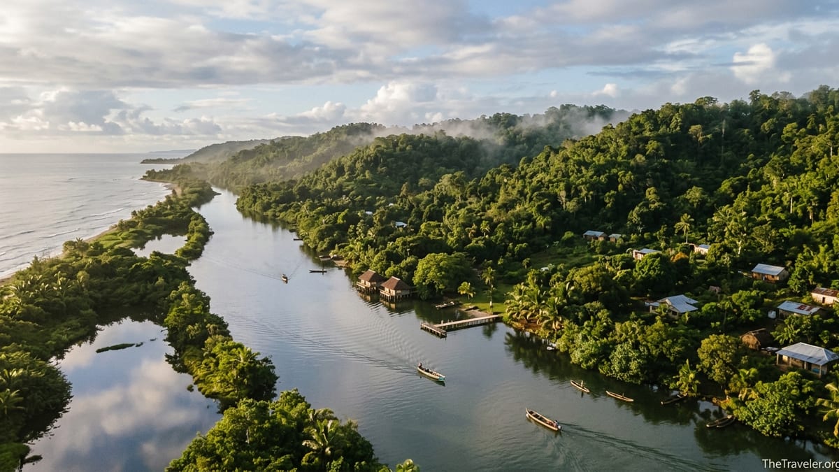
Eastern Madagascar is the country’s green, dripping edge, where rainforest meets the Indian Ocean and the historic Pangalanes Canal threads past lakeside villages. It is also one of the wettest, most weather-exposed regions in the Indian Ocean. Rain falls in every month, cyclones routinely hit the coast, and a landslide or flooded track can turn a four-hour transfer into an all-day detour. Yet for travelers prepared to time their trip and pack for serious humidity, the rewards are immense: misty morning walks with indri lemurs in Andasibe, long boat days on the Pangalanes and relaxed beach time around Toamasina or quiet lakeside lodges.
Understanding Eastern Madagascar’s Climate
Madagascar’s east coast, from Andasibe and the Alaotra-Mangoro region down past Toamasina and the Pangalanes Canal, has a classic trade-wind tropical rainforest climate. Moist air from the Indian Ocean hits the escarpment and drops rain throughout the year. Even in what locals call the dry season, showers are common, and you should expect wet trails, slick roots and at least some mud on almost any multi-day itinerary.
In lowland cities like Toamasina, average temperatures stay relatively stable across the year, typically in the mid-20s Celsius, with slightly hotter conditions in January and February and slightly cooler days in July and August. Nights inland around Andasibe are cooler, especially from June to August, when a fleece and light hat feel welcome on pre-dawn walks. The important shift is not from hot to cold but from extremely wet months to months that are simply wet.
For trip planning, it helps to think of the year in three broad phases. January to March is peak cyclone and heavy-rain season, when disruption risk is highest. April to June is a transition to cooler, less stormy conditions. July to October is generally the most settled period for boat trips and road transfers, with more comfortable temperatures for hiking. November and December gradually ramp back into the hot, humid buildup to the next cyclone season.
January to March: Peak Rains and Cyclone Risk
From January through March, the humid east is at its most dramatic. The Intertropical Convergence Zone and warm Indian Ocean fuel frequent downpours, and the official cyclone season for Madagascar peaks in this window. In recent years, strong systems have repeatedly made landfall around Toamasina, flattening houses and causing major flooding in the port and surrounding low-lying villages. This is the period when news outlets most often carry images of damaged coastal roads, evacuated communities and washed-out bridges.
For travelers, this does not mean eastern Madagascar is off limits, but it does mean accepting a higher chance of disruption. Road transfers on RN2 from Antananarivo to Andasibe and Toamasina can take significantly longer after heavy rain, with slow-moving truck traffic, fog on the higher passes and occasional landslide clean-up. Some secondary routes and rural tracks simply become impassable. A taxi-brousse that might cover the distance in seven to eight hours in September can take several hours longer in February if rain has undercut the verges or traffic is held up by fallen trees.
Out on the Pangalanes Canal, water levels are high and vegetation is at its lushest, but strong winds and heavy squalls can make crossings of large lakes choppy. Local boat operators sometimes delay departures for a few hours, or even a day, if a cyclone is approaching or has just passed. Lakeside lodges such as those near Manambato or Palmarium may find that their simple wooden jetties are partially submerged, and boarding requires wading through ankle-deep water. If your schedule is tight or you must connect with an international flight on a specific date, this level of uncertainty can be stressful.
Wildlife viewing, however, can still be excellent. Many guides in Andasibe comment that the forest feels “alive” in the wet period: amphibians are active, invertebrates are abundant and the vegetation is intensely green. The trade-off is comfort. Trails turn into flowing streams during heavy showers, and a three-hour circuit can mean walking in mid-calf mud. If you are determined to travel between January and March, it is wise to book flexible, private transfers rather than fixed shared shuttles, keep at least one buffer day before any flight, and purchase travel insurance that explicitly covers weather-related delays.
April to June: Transition to Cooler, Calmer Conditions
From April into June, the east coast shifts into a more forgiving rhythm. Cyclone risk drops noticeably by late April in most years, though out-of-season storms are not impossible, especially with climate variability. Rains remain frequent, but instead of day-long deluges you are more likely to encounter heavy showers interspersed with bright, sunny spells. For many visitors, this is a sweet spot: the landscape is still lush from the preceding months, but logistics become more predictable.
Andasibe-Mantadia National Park is particularly rewarding in May and June. The forest canopy is full, but trails have started to dry out compared with February and March. Indri, the park’s emblematic lemur, call loudly at dawn on cool, misty mornings, and the more moderate temperatures make four- to five-hour walks comfortable, especially for families or those not used to tropical humidity. Basic lodges and mid-range hotels along the park road often run at slightly lower rates than in peak European holiday months, so you may find better value on rooms and guiding.
Along the Pangalanes Canal, April and May bring clearer travel days. Local agencies in Toamasina and Manambato report that multi-day boat trips to lakeside reserves and fishing villages are easier to schedule, with fewer cancellations for storms. The water is still warm enough for swimming off sandy islets, and you are likely to share the canals with more local transport pirogues than foreign visitors. On the coast itself, beach stays near Foulpointe or Mahambo are more relaxed before local school holidays and the July–August rush, while sea conditions for short motorized pirogue excursions to offshore reefs are often manageable, though always subject to the Atlantic-like power of the Indian Ocean swells.
Road reliability also improves. RN2 remains a busy, winding corridor filled with freight trucks to and from the port, but the risk of the kind of major washouts often seen at the height of the rains is lower. A private driver departing Antananarivo after breakfast can normally reach Andasibe by early afternoon in this period, and Toamasina by early evening, barring construction works or accidents. If you want a balance of green landscapes, active wildlife and fairly dependable transfers, April to June works well.
July to October: Prime Time for Trails, Boats and Roads
Between July and October, the eastern escarpment and coastal strip settle into their most reliable stretch of the year. It is not a dry season in the sense that you might experience in southern Africa, but rainfall intensity usually drops, and showers are more often brief or night-time. Temperatures inland around Andasibe are comfortably cool, with some visitors comparing a July dawn there to a fresh spring morning in southern Europe. On the coast, daytime highs are a little lower than in January, and humidity, while still present, is less oppressive.
For rainforest walks, this is typically the best window. Trails in Andasibe-Mantadia, Analamazaotra Special Reserve and nearby community forests are still moist but not permanently waterlogged. Sturdy hiking shoes with good grip are normally sufficient, with knee-deep mud less common than in the wettest months. Guides can more easily follow lemur troops through the undergrowth without battling continuous downpours, and birders appreciate the crisper, less hazy light for photography. Many international operators schedule their Madagascar small-group departures in September and October for precisely these reasons.
The Pangalanes Canal also comes into its own in this period. Several operators that run simple but comfortable canal cruises or lodge-to-lodge boat transfers specifically highlight May to October as their preferred season because lake crossings are smoother and there is less risk of itineraries being halted by storms. In August or September, a traveler might spend a full day moving by wooden motorized barge from Manambato past reed beds and river mouths, stopping at small villages where schoolchildren greet visitors at the landing. While a squall can still blow through, it is less likely to cancel the entire day’s journey.
Road conditions are accordingly more favorable. Although RN2 always demands caution because of heavy trucks and curves, it is generally at its least problematic between July and October. This is the time when a road trip that links Antananarivo, Andasibe, the Pangalanes Canal and back in a 10-day loop is most realistic without building in large buffers. Car rental with driver, which might cost in the range of 60 to 80 euros a day for a standard vehicle, is money well spent in this region; during these months, that investment buys not just safety but also a good chance that your planned schedule will actually hold.
November and December: Humid Build-Up and Wildlife Highlights
As November and December arrive, humidity ramps up again along the east coast, and afternoon thunderstorms become more frequent. Cyclone season is officially under way by November, but the highest concentration of severe storms still lies a few weeks ahead, so many travelers use this period to enjoy early wet-season wildlife activity while keeping a lower, though not zero, disruption risk than in January or February.
In Andasibe, some lemur species give birth in late spring and early summer, and visitors in November may have the chance to see mothers carrying small infants through the canopy. Reptiles and amphibians become more visible, and the forest floor is alive with insects. Daytime temperatures climb, so early starts become even more important: a 6:00 am departure allows you to cover the longest trails before the air turns heavy. Mosquito activity increases, particularly around dusk, so long sleeves and reliable repellent are essential for both comfort and malaria prevention.
On the Pangalanes Canal, November and early December days can feel particularly atmospheric: still mornings with mirror-like water, low clouds over the forest, and dramatic late-afternoon squalls that send locals hurrying to pull pirogues higher onto the sand. Boat captains start paying more attention to cyclone bulletins, and local authorities may issue temporary navigation restrictions if a developing system threatens the coast. Flexible itineraries and a willingness to adjust your plan on short notice are important.
Coastal stays around Toamasina and smaller east-coast towns can still be enjoyable in this window. Sea temperatures are inviting, and local markets are full of seasonal fruit. However, travelers should acknowledge that an early-season cyclone could bring several days of intense rain and rough seas, forcing excursions to be postponed. Travel insurance that covers trip interruption and additional accommodation costs is particularly useful if you book November or December trips along this part of Madagascar.
How Weather Shapes Wildlife Walks, Boats and Roads
Eastern Madagascar’s consistently humid climate does not affect every activity in the same way. Understanding these differences can help you slot destinations together intelligently. For rainforest walks in Andasibe-Mantadia and neighboring reserves, the key variables are trail conditions, leech and insect activity, and temperature. The wettest months from January to March mean very muddy paths and slippery inclines, with some sections temporarily closed by park authorities for safety. Waterproof boots and trekking poles become almost essential then. By contrast, July to October offers firmer footing and cooler air, so longer circuits and add-ons such as Mantadia’s hillier trails are more realistic for most visitors.
Boat travel on the Pangalanes Canal responds more directly to wind and storm frequency than to everyday rainfall. Short showers do not usually stop standard motorized pirogue transfers between Manambato and lakeside lodges, which often run year-round. It is the combination of strong winds, high waves on exposed lake sections and cyclone warnings that lead captains to delay or cancel. For multi-day canal journeys, such as a three-day cruise south from Toamasina, trip organizers are far more likely to run full programs between May and October, when these risks are relatively lower, and to build in spare days in February or March for weather-related adjustments.
Roads form the backbone of almost any eastern itinerary, from the paved RN2 to dirt access tracks down to lakes and small coastal communities. RN2 itself, linking Antananarivo, Andasibe and Toamasina, is one of Madagascar’s priority routes, so it receives more maintenance than many other roads. Still, heavy rains between January and March can create potholes quickly, and landslides occasionally close one lane or require temporary diversions. Secondary roads, such as those used to reach canal embarkation points or smaller beach villages, are more vulnerable. In a very wet week, a simple clay track that a standard sedan managed in September may require a high-clearance 4x4 or become inaccessible in February.
When planning, it helps to imagine specific days. For example, in October you might safely schedule a morning transfer from Andasibe to Manambato, a midday lake crossing by boat and an afternoon check-in at a canal lodge, all in one day. Attempting the same sequence in late February would be more risky; a single storm-delayed boat or road blockage could force you to overnight en route. A good local agency or driver-guide will adjust the order of stops based on current conditions, but you should still avoid back-to-back commitments such as finishing a canal trip and flying home the same evening during the peak wet months.
Packing for a Humid East Coast Itinerary
Because rain is a year-round reality in eastern Madagascar, your packing list should start with weather resilience rather than assuming you will luck into dry days. A lightweight, breathable waterproof jacket is essential for forest walks and boat rides. In the hottest months, many travelers prefer a packable poncho, which allows more airflow while still shedding heavy showers. Quick-drying hiking trousers and synthetic or merino T-shirts are far more practical than heavy cotton, which stays damp and clammy after a downpour.
Footwear deserves particular attention. For Andasibe’s trails, sturdy trail runners or light hiking boots with good grip are ideal most of the year. Between January and March, or if you know you will be tackling longer routes in Mantadia, consider bringing knee-length gaiters or rubber boots, which can often be purchased in Antananarivo’s markets or borrowed from some lodges. Simple plastic sandals or flip-flops are invaluable for boarding canal boats in shallow water and for moving around wet lodge decks.
Humidity also shapes what you pack for comfort and health. A compact travel umbrella is useful for quick dashes between your bungalow and the dining area in heavy rain, while a dry bag or roll-top backpack liner protects cameras and documents on boat days. High-quality mosquito repellent, long-sleeved shirts and light trousers are important in the evenings, especially near lakes and lowland coast, where malaria risk is present. Many lodges provide mosquito nets, but carrying a small repair kit or a spare travel net can be reassuring if you are visiting more basic properties.
Finally, plan for the possibility of delays. A small power bank keeps phones and e-readers charged during longer-than-expected transfers, and a physical paperback is handy if a storm keeps you at a canal lodge for an extra day. Some travelers bring compact water-resistant bags of snacks, such as nuts, dried fruit and biscuits bought in Antananarivo or Toamasina supermarkets, to make unexpected roadside waits more comfortable. In a region where weather can quickly rearrange plans, these small preparations can make a big difference to your overall experience.
The Takeaway
Eastern Madagascar rewards those who embrace its moisture and unpredictability. This is not a region where you chase clear blue skies; it is a place where mist hangs in the forest, afternoon showers cool overheated villages and the sound of rain on a tin roof is part of the atmosphere. Rainfall is possible in every month, and cyclone season from roughly January to March introduces a genuine possibility of disruption, particularly along the low-lying coast.
If your priority is reliable logistics and comfortable conditions for rainforest walks, boat journeys and coastal stays, aim for the window from July to October, or the transition months of April to June. If you are keen to experience peak amphibian activity and intensely lush forests and are willing to accept higher disruption risk, the shoulder periods of November and early December, or even parts of the wet season, can still be rewarding. Whichever month you choose, approach eastern Madagascar with flexibility, pack for serious humidity and partner with local guides and operators who understand how weather patterns affect specific trails, boats and roads in real time.
FAQ
Q1. Is there a completely dry month on Madagascar’s east coast?
There is no truly dry month in eastern Madagascar. Even in July or August, you should expect showers, though they are usually shorter and less intense than in January to March.
Q2. When is the best overall month to combine Andasibe, Pangalanes and the coast?
September is often an excellent compromise, with relatively reliable roads, good conditions for canal boats, cooler temperatures and generally manageable rainfall.
Q3. Is it safe to visit eastern Madagascar during cyclone season?
Many people still travel between January and March, but you face a higher risk of cancelled boats, delayed road transfers and power cuts, especially around Toamasina and low-lying coastal villages.
Q4. Do Andasibe’s trails close in heavy rain?
Park authorities may temporarily close specific trails or restrict access if conditions become unsafe due to landslides, fallen trees or flooding, most commonly during the wettest months.
Q5. Can Pangalanes Canal boats run in the rain?
Boats usually keep operating in normal rain, but strong winds, rough lake conditions or cyclone warnings can lead captains and authorities to postpone or cancel departures.
Q6. Are roads from Antananarivo to Andasibe and Toamasina paved?
RN2, which links Antananarivo, Andasibe and Toamasina, is paved throughout, but it is winding, busy with trucks and vulnerable to potholes and minor landslides during very wet periods.
Q7. What footwear should I pack for rainforest walks?
Pack sturdy trail shoes or light hiking boots with good grip. In the wettest months, consider rubber boots or gaiters for deep mud on some Andasibe and Mantadia trails.
Q8. Do I need malaria tablets for eastern Madagascar?
Malaria risk exists along the east coast and around lakes and canals, so speak to a travel health specialist about appropriate prophylaxis and always use repellent and bed nets.
Q9. Is swimming possible along the east coast and Pangalanes?
Swimming is often possible in sheltered canal lakes and at some beaches, but strong currents and waves mean you should follow local advice and avoid the open ocean in rough conditions.
Q10. How much flexibility should I build into my itinerary?
In the drier months, one or two buffer days are usually enough. During peak rains and cyclone season, consider adding extra slack, especially before flights or long international connections.