


Madagascar looks compact on the map, but once you land in Antananarivo you quickly realise that distances are long, roads are slow and you will not see everything in one trip. The key to a great itinerary is not ticking off the most famous names, but choosing a realistic route that matches your interests, travel style and the time you have. This guide compares Madagascar’s headline regions and shows how they link together in the real world, so you can decide whether to chase indri calls in misty rainforest, hike sandstone canyons, walk among stone "tsingy" pinnacles or relax on a coral-fringed island beach.
How to Think About Distances, Seasons and Budget in Madagascar
Madagascar rewards travelers who slow down. Paved national highways can average 30 to 50 kilometers an hour once you factor in village traffic, potholes and occasional roadworks, while unpaved tracks to places like Tsingy de Bemaraha often feel more like expeditions than transfers. A route that looks like a simple loop on the map can mean full days in a vehicle. For example, the 150 kilometers from Antananarivo to Andasibe typically takes around 3 to 4 hours by private car, even though almost all of it is on sealed road. By contrast, the journey from Morondava to the village of Bekopaka, staging point for Tsingy de Bemaraha, is often a 10 to 12 hour day in the dry season with river crossings and rough tracks.
Season matters as much as distance. The bulk of international visitors travel between April and October, which tends to bring drier roads for the RN7 southbound route to Ranomafana and Isalo, better access to Tsingy in the west, clearer water around Nosy Be for snorkeling and diving, and slightly cooler nights in the highlands. The cyclone season, roughly January to March, can bring heavy rains that damage roads and force internal flight schedule changes. Some parks or remote tracks may close temporarily if rivers rise or bridges are damaged, which is one reason most reputable Madagascar specialists recommend building slack days and flexibility into any ambitious itinerary.
Budget also shapes your route. Crossing Madagascar overland by taxi-brousse, the shared minibus system, is far cheaper than hiring a private 4x4 with driver, but travel times are unpredictable and departures cluster in daylight hours. On the main RN7 axis, travelers regularly pay a reputable company like Cotisse VIP for a seat in an air-conditioned bus between Antananarivo and Antsirabe or Fianarantsoa, and then hire local taxis or drivers onward. In contrast, a private 4x4 with driver for a tailor-made route can run roughly the price of a mid-range European hotel night per day, but the driver handles permits, fuel stops and en route changes, which can save a lot of stress when you have limited time.
Internal flights can save days. Typical examples include hopping from Antananarivo to Nosy Be in about 1 hour 45 minutes on a direct flight, or flying back from Tulear after Isalo to avoid driving the RN7 in reverse. However, domestic flights are not as frequent or as punctual as in Europe or North America. Travelers often plan at least one buffer night in Antananarivo before any intercontinental flight, and avoid same-day connections that rely on both a domestic flight and a long road transfer.
Antananarivo: Gateway and Cultural Stopover
Virtually every international traveler starts and ends in Antananarivo, known locally as Tana. Sitting on a plateau of rice paddies and ridges, it is more gateway than main destination for most visitors, but a night or two can add context to your trip. The upper town has narrow streets, colonial architecture and views over the hills, while markets in districts like Analakely show the bustle of modern Malagasy life. For many travelers, the main practical reasons to pause in Tana are to recover from jet lag, meet a local operator, and adjust to the slower pace before heading to rainforests or the coast.
From a logistics point of view, Antananarivo is the main hub for domestic flights to Nosy Be, Antsiranana, Tulear and Sainte-Marie, and the starting point for the two main overland corridors: the RN2 east toward Andasibe and the RN7 south toward Ranomafana and Isalo. Airport hotels and guesthouses near Ivato allow late arrivals to sleep near the terminal, while city-center hotels in the Ivandry or Isoraka neighborhoods suit travelers with a full day to explore. Many tour operators schedule city sightseeing only at the end of a trip, once travelers have more context and are less likely to be too tired to appreciate it.
How long you spend in Tana depends on your connections. If you are arriving from Europe on an evening flight and continuing by road to Andasibe the next day, an overnight city stay is usually enough. If your plan involves juggling multiple domestic flights, consider at least two separate nights in Tana spread across the trip, used as buffers in case of delays. Antananarivo pairs naturally with Andasibe to the east or with a southbound RN7 route, and it also combines well with a Nosy Be or Sainte-Marie beach finale reached by air.
Andasibe: Easiest Access to Indri Lemurs
If your dream image of Madagascar is waking to the haunting call of the indri, the largest living lemur, Andasibe-Mantadia National Park is your most straightforward bet. Located around 150 kilometers east of Antananarivo along the RN2, it is one of the few rainforest reserves that can be reached on a mostly paved road in half a day. Many visitors arrive by private car and driver, often arranged by a local agency or their hotel, but it is also possible to go by taxi-brousse to Moramanga and connect to a local minibus onward to the village of Andasibe if you have time and patience.
Andasibe works especially well for short trips. With three nights in Madagascar, a common pattern is to overnight in Antananarivo on arrival, then drive to Andasibe for one or two nights to walk in the Analamazoatra Reserve at dawn, listen for indri calls and look for other diurnal lemurs, then do a night walk along the roadside forest edge, before heading back to Tana. Lodges clustered near the park entrance range from simple bungalows to more polished ecolodges with restaurant terraces overlooking forest and ponds. Hiring a local guide at the park entrance is mandatory, and fees are generally modest compared with park guiding costs in parts of East Africa.
In itinerary planning, Andasibe combines most naturally with Antananarivo and, for longer itineraries, with a domestic flight or onward drive. For example, many travelers do a 7 to 10 day circuit that starts in Tana, spends two nights in Andasibe, returns to the capital and then flies to Nosy Be or Sainte-Marie. Adding Andasibe to an already full RN7 route is possible but can make the schedule feel rushed, since it requires driving east and then doubling back through Tana before heading south.
Ranomafana: Classic Rainforest Wildlife on the RN7 Axis
Ranomafana National Park is one of Madagascar’s flagship rainforests and fits neatly into southbound itineraries along the RN7. The park lies near the town of Ranomafana, reached by turning off the RN7 near Fianarantsoa and following the RN25 and RN45 toward the Namorona River valley. From Antananarivo, overland travel via Antsirabe and Fianarantsoa usually takes two full days by private vehicle with an overnight in Antsirabe or Ambositra. Travelers using public transport often break the journey more, changing taxi-brousse in larger hubs.
Ranomafana is best for travelers who prioritize biodiversity and do not mind some rain and humidity. The park protects steep forested hills, rivers and waterfalls and is famous for several lemur species, including the golden bamboo lemur, which was described from this area. Trails range from short 2 to 3 hour circuits suitable for casual walkers to long, muddy hikes that require early starts and stamina. Most visitors stay in simple hotels or guesthouses along the main road near the park entrance, eating at on-site restaurants or local eateries in the village. Guiding is compulsory, and a guide with a spotter can significantly increase your chances of seeing lemurs and interesting chameleons.
In route planning, Ranomafana is a logical bridge between the highlands and the drier southwest. A classic pattern along the RN7 is to leave Antananarivo, overnight in Antsirabe, continue via Ambositra’s woodcarving workshops to Ranomafana for two or three nights of rainforest walks, then drive on to Isalo for hiking in sandstone canyons before finishing on the coast near Tulear or flying back to Tana. If your time in Madagascar is limited to about 10 days, including Ranomafana and Isalo in one trip is realistic, but adding Andasibe on top risks spending more time driving than in the forest.
Isalo: Sandstone Canyons and Accessible Hiking
Isalo National Park lies further south along the RN7, near the village of Ranohira, and offers a very different landscape from the eastern rainforests. Here, eroded sandstone massifs, deep canyons and pockets of gallery forest create one of Madagascar’s most dramatic hiking settings. The climate is drier and sunnier, particularly between April and October, and many visitors appreciate the open views after days of driving through highland farmland. Access is straightforward compared with more remote parks: you arrive on the main north-south highway and sleep in a lodge along the road or on the edge of the massif, then enter the park with a local guide for day hikes.
Isalo is best for travelers who enjoy moderate day hiking and striking scenery rather than dense wildlife encounters. Typical circuits include 4 to 6 hour walks past rock formations, natural pools where swimming is possible, and viewpoints that are especially impressive near sunset. The network of trails allows guides to adapt routes to your fitness level. Accommodation options near Ranohira range from basic roadside hotels to stylish lodges set among boulders, often with swimming pools where travelers cool off after hikes. Compared with some rainforest regions, nights here can feel more comfortable due to lower humidity, though daytime temperatures in October and November can be hot.
In an itinerary, Isalo links naturally with Ranomafana to the north and the coastal city of Tulear to the south. Many two week RN7 trips use a rhythm of one night in Antsirabe, two or three in Ranomafana, two or three in Isalo and one or two near the coastal spiny forests around Ifaty or Anakao. Travelers who are short on time sometimes fly back from Tulear to Antananarivo after Isalo, which reduces road time but adds cost and the need to watch domestic flight schedules closely. Isalo does not pair efficiently with Tsingy de Bemaraha in a single short trip, because traveling between the RN7 corridor and Morondava requires crossing the highlands again.
Morondava and Tsingy de Bemaraha: Baobab Avenues and Adventure Tracks
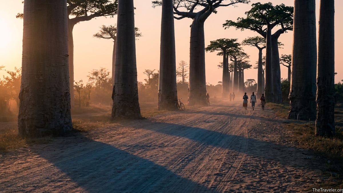
On Madagascar’s west coast, Morondava is the jumping-off point for two of the country’s most iconic sights: the Avenue of the Baobabs and the tsingy limestone pinnacles of Tsingy de Bemaraha. Morondava itself is a laid-back coastal town with simple seaside hotels, a sandy beach and a working port atmosphere. The Avenue of the Baobabs lies inland along a dirt road and can be reached from town in around 45 minutes to an hour. Many travelers hire a local driver for an afternoon and sunset trip, watching the massive trees glow orange as the light softens, and sometimes return again at sunrise to photograph the silhouettes in the morning mist.
Reaching Tsingy de Bemaraha is a much more serious undertaking. From Morondava, the route follows the RN8, an unpaved track that runs north via the village of Belo sur Tsiribihina and on to Bekopaka. In the dry season, private 4x4s and organized tours typically take a full day each way. The journey involves at least one river crossing by barge, rough stretches of sand or corrugated dirt and occasional delays if a vehicle gets stuck or if water levels remain high after rain. Bekopaka has a handful of basic and mid-range hotels that act as bases for day trips into the Tsingy de Bemaraha National Park, where harnessed via ferrata style routes, ladders and suspension bridges let you move across the sharp pinnacles.
Morondava and Tsingy are best for travelers who have a strong appetite for adventure and are comfortable with basic infrastructure and long drives. A realistic minimum time frame from Antananarivo is five to six days: one to fly or drive to Morondava, one for the Avenue of the Baobabs and transfer north, two full days for visiting the small and big tsingy formations, and one or two days to return. Flying to Morondava from Tana cuts road time but domestic flights can be limited or changeable, so many itineraries combine Morondava and Tsingy with a more flexible segment like Nosy Be or the RN7 rather than trying to add them to an already tight schedule.
In broader route design, Morondava pairs most naturally with Tsingy itself or with a coastal extension north or south, but combining it with both the RN7 and the northern cap in a single two week trip is usually unrealistic. Some operators offer longer three week itineraries that start with Andasibe, continue to Morondava and Tsingy, then cross the highlands to join the RN7 southbound. These can be memorable but are best suited to travelers who are comfortable with consecutive long road days and willing to accept that delays are part of the experience.
Nosy Be and Sainte-Marie: Beach Time, Diving and Whale Watching
For many visitors, a stay on an offshore island is the reward at the end of a dusty road trip. Nosy Be, off Madagascar’s northwest coast, is the most developed beach destination, with an international airport, a cluster of mid-range and upscale resorts and a range of dive centers and excursion operators. Direct flights from Antananarivo take about 1 hour 45 minutes and are scheduled most days, which makes Nosy Be reasonably easy to bolt onto either a short Andasibe-focused trip or a longer RN7 journey. Once you arrive, most hotels provide airport transfers, and getting around the island often involves local taxis or arranged excursions by boat to neighboring islets like Nosy Komba or Nosy Tanikely.
Nosy Be is best for warm, relatively calm seas, snorkeling over coral, scuba diving and sunset cocktails rather than raw wilderness. The island has infrastructure for families and couples who want comfort after more basic nights inland, with air-conditioned rooms, beachfront restaurants and, in some areas, lively nightlife. That said, parts of the coastline remain quiet, especially if you choose smaller lodges on outlying beaches rather than the busiest stretches. Typical stays run from three to six nights, long enough to mix boat trips and dives with rest days by the water.
Sainte-Marie, also known as Nosy Boraha, sits off Madagascar’s east coast and has a more low-key, castaway feel. Access is usually via a domestic flight from Antananarivo to the island’s small airstrip, sometimes combined with a boat transfer if sea conditions and schedules allow. Between roughly July and September, humpback whales migrate through the channel between Sainte-Marie and the mainland, and local operators offer whale-watching trips in small boats that follow regulations on approach distance. Outside whale season, Sainte-Marie is still attractive for palm-lined beaches, coastal cycling and small guesthouses, but sea conditions can be rougher than around Nosy Be.
In itinerary design, Nosy Be combines naturally with northern mainland highlights like Antsiranana and the tsingy formations of Ankarana, because ferries and boats connect the island with ports to the north. Sainte-Marie pairs more easily with eastern rainforest routes such as Andasibe or the less visited Masoala region. Adding both islands plus a full RN7 circuit in a single two week trip generally means more flights and short stays; many travelers instead choose one beach destination and give it at least four nights for a proper unwind at the end.
Antsiranana and the Northern Region: Bays, Tsingy and Emerald Seas
In the far north, the region around Antsiranana, still widely known by its colonial name Diego Suarez, offers a mix of bay scenery, smaller tsingy formations and access to one of Madagascar’s most photogenic lagoons. Antsiranana itself sits on a dramatic natural harbor fringed by old fortifications and a mix of colonial and Malagasy architecture. The climate here is warm and breezy for much of the year, and the town acts as a hub for excursions to places like the Emerald Sea, a shallow turquoise lagoon north of the city, and to the Montagne d’Ambre National Park, where montane rainforest shelters lemurs and waterfalls.
Further west, the Ankarana Reserve protects limestone tsingy formations, caves and dry forest, and is often combined with the northern itinerary. Reaching Antsiranana generally requires a domestic flight from Antananarivo, although hardy travelers with plenty of time sometimes overland via Ambanja and Ankify. Once in the region, movements are mostly by private vehicle or organized excursion, as public transport options to trailheads and remote villages are limited. Accommodation ranges from basic guesthouses in town to ecolodges closer to the parks.
The north is best for travelers who want varied scenery and lighter hiking without the long, rough transfers of Tsingy de Bemaraha or the humidity of Ranomafana. A common pattern is to fly from Tana to Antsiranana, spend two or three nights exploring the bays and Montagne d’Ambre, continue south by road to Ankarana for another two nights of tsingy walks, then transfer to Ankify to board a boat across to Nosy Be for several days on the beach before flying back to Antananarivo. This creates a compact northern circuit that focuses more on landscapes and light adventure than on hardcore trekking.
Putting It All Together: Sample Routes by Interest and Time
Because infrastructure is limited and internal flights can be irregular, most successful Madagascar trips focus on one broad corridor, then add a complementary region if time and budget allow. For a 7 to 10 day trip that prioritizes lemurs and accessible forest, a realistic route would be Antananarivo, Andasibe for two nights, back to Tana, then a flight to Nosy Be or Sainte-Marie for four or five nights of beach time. This minimizes long drives and uses short flights to shift between rainforest and sea, which works well for travelers who prefer comfortable lodges and day excursions over multi-day road journeys.
For a first visit of about two weeks with a mix of wildlife, landscapes and local culture, the RN7 corridor is hard to beat. A typical pattern is Antananarivo, Antsirabe for one night, two or three nights in Ranomafana for rainforest walks, two or three nights in Isalo for hikes and canyon scenery, and then one or two nights on the southwest coast near Tulear or Ifaty to see spiny forest and coastal villages. If budget allows, a flight from Tulear back to Tana can save time and energy. This route can be adjusted to include more or fewer nights in each stop depending on whether you lean more toward wildlife watching or hiking.
Travelers with closer to three weeks and a taste for adventure might design a loop that includes both the RN7 and the west coast. For example, you could start in Antananarivo, drive or fly to Morondava to see the Avenue of the Baobabs and, if road conditions allow, continue to Tsingy de Bemaraha for several days of exploration. After returning to Morondava, you would cross back through the highlands to join the RN7, visit Ranomafana and Isalo, and then decide whether to finish on a southwest beach or fly back to Tana for a final city night. This sort of itinerary demands flexibility and a buffer of at least one or two unallocated days to absorb delays.
Another coherent strategy is to focus entirely on the north. A northern circuit of Antananarivo, Antsiranana and its bays, Ankarana and Nosy Be creates a satisfying combination of light hiking, limestone formations, village visits and beach time with less temperature contrast and, often, less road weariness than a west or RN7 itinerary. It also works well outside the peak European holiday months, as long as you check local guidance on any seasonal winds or sea conditions that might affect boat transfers to or from Nosy Be.
The Takeaway
Madagascar is not a place to rush. The parks and coastal regions that make the country unique are separated by long, slow journeys and, in some cases, by domestic flights that can shift with limited notice. The most rewarding trips are built by choosing a small number of regions that genuinely fit your priorities, then accepting that there will be other forests, canyons, baobab groves and beaches left for a future visit. For many first-time visitors, that might mean choosing between an RN7 focus with Ranomafana and Isalo, a northern arc through Antsiranana and Nosy Be, or an east-and-islands combination of Andasibe and Sainte-Marie, rather than trying to see it all.
As you refine your route, keep asking three practical questions. First, what is this place best for, whether that is indri calls, tsingy adventures, whale watching or simple hammock time. Second, how hard is it to reach in the season you are traveling. Third, how well does it connect with the rest of your plan without leaving you stranded in a taxi-brousse depot the day before your flight home. By being realistic about distances and road conditions, and by allowing margins for the unexpected, you give yourself the best chance of experiencing the Madagascar you imagined when you first saw a photograph of a lemur leaping across a rainforest gap or a baobab silhouetted against a setting sun.
FAQ
Q1. How many days do I need for a first trip to Madagascar?
For a meaningful first visit that includes at least one national park and some time on the coast, aim for 12 to 16 days on the ground. One week is enough for a focused Andasibe and Nosy Be or Sainte-Marie combination, but you will spend a larger share of your time in transit.
Q2. Is it better to travel Madagascar by public transport or with a private driver?
Public transport by taxi-brousse is much cheaper and can be an adventure in itself, but departures and arrivals are unpredictable and comfort is basic. Hiring a private car and driver costs more but gives you control over stops, routes and timing, which is especially valuable if you have limited vacation days.
Q3. When is the best time of year to visit Madagascar for wildlife?
Wildlife is present year-round, but the period from roughly April to October usually offers a good balance of drier trails, more reliable road conditions and comfortable temperatures. If you want whale watching around Sainte-Marie, aim for mid-year months, and if you want young lemurs in the rainforests, late spring can be rewarding.
Q4. Can I combine Tsingy de Bemaraha with Isalo and the RN7 in a two week trip?
It is technically possible but will be very rushed and vulnerable to delays. The long, rough transfers to Tsingy from Morondava alone can consume several days. Most travelers either focus on the RN7 with Isalo and Ranomafana or build a west-and-tsingy itinerary, rather than trying to do both in a short window.
Q5. Do I need to book domestic flights in Madagascar far in advance?
It is wise to secure domestic flights as early as you can, especially in the European summer and around local holiday periods. Schedules and operating days can change, so many travelers also keep one or two flexible days and avoid planning tight same-day connections with international flights.
Q6. Is Andasibe suitable for families with children?
Yes, Andasibe is one of the most family-friendly parks because access is straightforward from Antananarivo, walking trails can be kept relatively short and you have a good chance of seeing indri and other lemurs without long, strenuous hikes. Lodges in the area are used to hosting families and can arrange early dinners and simple meals.
Q7. How physically demanding is hiking in Isalo National Park?
Most standard circuits in Isalo are moderate rather than extreme. Expect 4 to 6 hour walks on uneven ground with some short climbs and descents. Guides can adapt routes to your fitness level, and there are often opportunities to cool off in natural pools, but anyone with mobility issues should discuss options in advance.
Q8. Are Nosy Be and Sainte-Marie very touristy?
Nosy Be is Madagascar’s most developed beach area, with larger resorts and more nightlife in certain bays, though quieter corners still exist. Sainte-Marie is more low-key, with smaller guesthouses and a village feel, especially outside the whale season when visitor numbers peak.
Q9. How far in advance should I book accommodation near the main parks?
In popular areas like Andasibe, Isalo and Nosy Be, it is sensible to book at least a few months ahead for travel in the European summer or local school holidays, especially if you prefer specific lodges or room types. In shoulder seasons, you may find more flexibility, but remote areas still have limited bed capacity.
Q10. Is Madagascar safe for independent travelers?
Most independent travelers report positive experiences, but you should take standard precautions such as avoiding walking alone late at night in cities, using reputable drivers or transport companies and keeping valuables secure. The larger risks usually relate to road conditions and delays rather than to personal security, so building margin into your schedule is part of traveling safely.